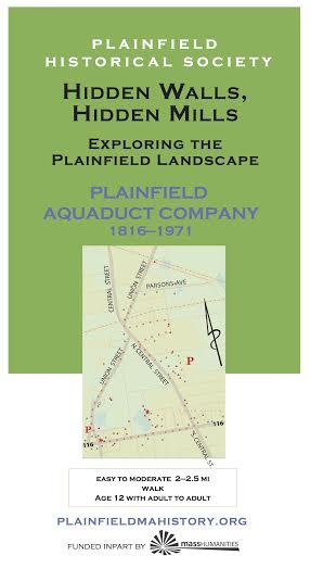
Plainfield Aquaduct Company
Click here for Plainfield Aquaduct Map
Without clean water, we cannot exist. Before deep, drilled, wells, clean water was tough to find where houses were built side-by-side. In 1816, the residents of the center of town formed the Plainfield Aquaduct Company (PAC), piping water from the many springs up the hill.
Learn about geology and the historical methods of providing water, the use of springs. See one of the original pipes of the PAC, and explore some of the many springs that made the center of Plainfield possible. Note: This walk is best taken in early Spring right after the snow melts when the springs are most active.
This tour threads in and out of fields and the cemetery to more or less follow the route of the pipeline of the Plainfield Aquaduct Company, but not cross private fields or yards. One field has a bull in it. In some cases, you are asked to “sight” along the line of a wall or in extension of it to imagine how the pipe ran until the 1970’s, some of which is still lying around as marked on the map. Parts of the walk can get fairly overgrown.
★ Start on North Union Street just past Parsons Ave. Find the spring box in the woods to the right of the powerline right-of-way. Then follow the snowmobile trail down the hill and turn right onto Parsons to pick up the pipe a little lower down. Then turn left onto North Union, and another left onto Hilltop Cemetery, where we invite you to linger. Many of the PAC principals are buried here. Follow the cemetery wall all the way around, and repeat a similar maneuver around the firehouse. Then walk down the road to Main Street, where the main pipe crossed the road and ended. Turn right onto main to follow the branch that led to the school. Circle behind the library to see some other spring activity, continue down Main and up Union Street back to your car, all the while noting springs, rushing water under grates and narrow lots for pipeline right of way on the map.
P: Park behind the Church or Town Hall, at the Ball Park, or off the side of the road by the power lines after Parsons Ave.
Printing PAC: Click on the brochure (R) to download (11 MB). Use 8 1/2 x 14 (legal) size paper, portrait orientation; turn off automatic sizing, scaling, and text orientation (important*); fold in three with the map on the inside. You should be able to fold the text up and down to consult it and map in turn. [*Some newer printers want to flip the text panels on the text side. Make sure they remain upside down in relation to the map.]

Cistern at brick store
Dear Guest — a warning and a request:
Be careful: Wear sturdy shoes. Stone walls, cellar holes and their wells, and mill foundations are breathtaking and treacherous works of art. Do not ever climb on, in, or over them. If you make a wall come down, you will have destroyed it forever and you will be hurt. Cellphone: not so much.
Protect yourself against TICKS. You know what to do. If not: CDC
Walk softly. Pack out what you pack in, but leave rocks, plans, and any older metal or glass you happen to come across for the next adventurer to find. Recent trash: please pack it out.
Respect private land. The tours take you on publicly accessible land but the lot next door may be private. In general, if it isn’t posted you may go, but you should ask if you want to you to walk across someone’s field. ~ Thank you and enjoy yourself!